

Eh, close enough.
I was gonna say.
Want to see the map of Asia that most US-Americans could draw.
Nobody’s asking anyone to draw a map from memory. They’re asking a news channel to put in the 5 seconds of googling it takes to procure an accurate map.
============================== Russia ============================== Iran | China | Japan ============================== Saudi Arabia | India | Vietnam ==============================I’d add in Mongolia and call Myanmar Burma at first but otherwise, yeah.
Basically China, India and Japan with a Vietnam somewhere but they don’t want to talk about it.
Hey now, North Korea is in there somewhere by Vietnam, too.
No american knows India is in Asia. They think Asia is just south east Asia. I’ll allow that for the Brits tho
Why would you allow that for brits? India was a British colony you know?
?? By allow it I mean I’d understand if the shown map was what a Brit thought Asia was
China, India, Vietnam, Russia, Australia.
Probably Japan.
Maybe Tibet. Maybe Pakistan. Not sure about Afghanistan.
Australia would include Papua, Vietnam would get the rest of Southeast Asia, Indonesia, Malaysia, Philippines, Myanmar, you name it. It was a big war, must’ve been a big place. Who even knows what countries are there? It’s like the Balkans of Asia. India would look mostly the same, a bit bigger.
If Pakistan is included it probably would include Afghanistan as Afganistan is definitely in the Middle East and not in Asia, but Pakistan (If they remember it, with the weird border ritual video that became so popular) is so closely associated with India that there’s a chance it’s included. Maybe India gets Pakistan while Pakistan ends up around Iran.
China gets a lot of Kazakhstan, all of Mongolia and some of Russia. It’s possible some random chunk of western China gets the name Tibet. Russia stays mostly the same, whether they or China get the Korean peninsula is a toss-up. There’s a decent chance the Russian border just gets moved way north.
Depending on who you ask, Korea might also be included as it’s own thing. But it might end up in a weird place like Vladivostok, the Kola peninsula, or some place in China.
There’s a decent chance they know most of the main islands of Japan and it ends up looking a little cursed but mostly in the right place. I’m thinking it would either stop short of Hokkaido or seize Sakhalin.
Central Asia doesn’t exist.
deleted by creator
That’s cool and all, but if we’re directly correlating this, then I think it would be more like you drawing out the provinces in China or India.
China I could maybe get Manchuria, Inner Mongolia, Tibet kinda right, I’d try to get Guangdong, Szechuan and Xi’an, the rest I’m screwed (Heibei maybe? Guangzhou? Idfk). Perhaps I’d be better to stick to the 3 kingdoms.
India I’m much more screwed. Kashmir, North India, South India, Delhi, something called Gujurat maybe, Bengal, Pashtun?, Bombay, Goa? Throw the Ganges somewhere in there in the North and East…a desert in the west, North and South Mountains that are not called mountains? Now that I’m thinking about it, I’d probably draw it out as Kashmir, that big strip that hugs the Ganges and Himalayas where Delhi is, and Texas.
deleted by creator
Read a book.
I would hope you’d find Russia on a map too
Hmmm, never heard of it
You mean eastern Ukraine?
Removed by mod
#freetibet
#freehawaiiandtibet
#nobordersnonations
Tibet should be independent after Republic of China liberates the mainland of terrorists
The Republic of China also claims Tibet.
That’s irrelevant to “Tibet should be independent”
I do want to hear the difference between #FreeTibet and #FreeCaledonia and all other separatist movements. Hell even, #FreetheAmericaFromTheEuropeans
i wanna see the map of the USA that most USAians can draw
deleted by creator
I was going to be all proud and then I realized you said “most”…
Oof.
China and India are about right, Japan’s south of Taiwan, Vietnam is labeled South Korea, all the other islands are “you get the idea” squiggles. The rest is a wash. Anyone who remembers the Philippines is in the Armed Forces. Anyone who can place Thailand encrypts their hard drive.
All of central Asia is “Afghanistan?”.
If you had to condense it for a videogame, this would cover most bases.
Los Santos, Liberty City, Vice City.
And the big empty bit in the middle to hide the loading.
That’s just Red Dead.
GTA 7: Great Plains, Cacti, and Propane
I don’t get this though. Maps are free online. You don’t even have to guess anymore.
Exactly. Maps are free. Joke maps are also free. So instead of paying money, and somebody taking that money and assuring you this is the right thing. You get a free map, that might be a joke, but you don’t know it’s a joke cuz you don’t know the map. And we get some funnies
Where do they take maps from? 9gag? I mean, maps.google.com is free. It can’t be any easier.
I mean 9gag stands for 9 Good American Guys right? What better place to get your accurate American maps from?
Google images most likely
Yes, I’m sure using Google content on your commercial news channel is simple as can be.
You don’t have to use their content, but you can double-check that your map is correct, mister sarcasm.
Have you ever tried drawing a map from memory? It’s interesting, what you do and don’t remember and why. That’s why this is funny - what’s salient to the other person and what’s not. No American would want Florida to be bigger, for instance.
Honestly not far off
deleted by creator
I’m guessing this was an in-the-nutshell style meme, and they just didn’t know enough to sense the ironic oversimplification.
If you’re going off memory. Where did this image come from? Did the channel make it or did they grab it off a search?
How dare you split Michigan logically!
Can you explain to the non-US citizen the split in Michigan? If you want I can explain the split in Lorraine, France in exchange (^_^)
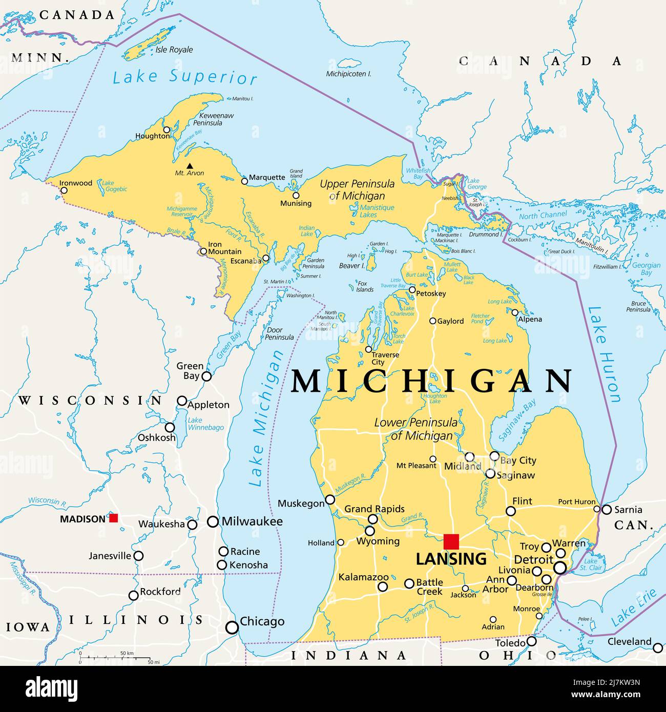
The state of Michigan exists on both sides of the great lakes (which are effectively freshwater oceans, containing their own maritime economies, marine salvage operations, maritime weather and even famous lost ships) so there’s the Michigan mainland which contains major cities like Detroit, Lansing, Ann Arbor and Grand Rapids, but then there’s the “upper penninsula” which is heavily wooded and some consider a continuation of the “north woods” of Wisconsin. Map for context:
Thanks.
As promise, here is the explanation for the split in Lorraine: Lorraine is a region in easter France that is culturally split in two. One part is of Frank culture, like Paris and French tradition, the other as a culture much closer to Germany, Luxembourg and german speaking countries. It also as a germanic tradition as local languages used to be some german dialect rather that french dialect.
This part of Lorraine which is roughly the Moselle county used to be called germanic Lorraine but this term started to be ambiguous when France lost Alsace, the very famously german-cultured region at the border of France and Germany, and the Moselle county in 1871.
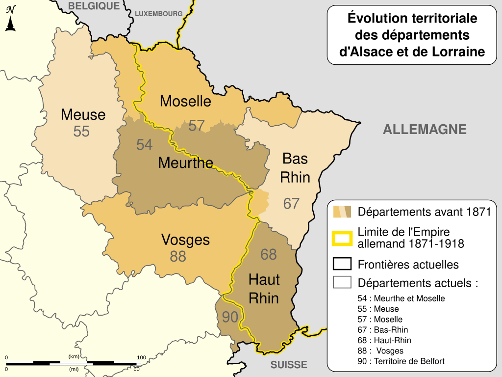
After the great war, Alsace-Moselle was part of France again, but as some of its social laws where better than France at the time, it was decided to keep them in place and not to apply the laws that where voted in France when it was part of German. Because of that, today Lorraine is separated not only culturally but also by laws in place. Go to Metz, on the germanic part, and have two more non-work holiday as in Nancy in the french. In Nancy and Metz, social contributions are calculated differently and important laws for France are not applied no the german side : Church and State are not separated there.
Of course, French State work on every day following that law but in Moselle and Alsace, men of worship can be pay with public money.
All that with having Nancy and Metz separated by 50 km and both being part of Lorraine.neat, thanks!
The very top parts of Texas and new York that touch are both part of Michigan. The disconnected bit in Texas is called the Upper Peninsula, and that’s basically Canada if you ask people (or listen to them talk).
A bit like a map on how Europe is perceived by Americans, where whole Germany is Bavaria.
As if Americans have any idea what Bavaria is. And if they could even name one city in Germany it certainly wouldn’t be anything in the south, it’d be Hamburg, because hamburgers lol
I feel like Berlin would be more famous, with it being the capital and the Berlin wall.
Don’t forget the Oktoberfest in Munich.
as an American, i was going to go berlin, munich, and then “that part in the south everyone seems to hate for being hicks”
Isn’t heidelberg super famous because of Elvis?
Not anymore.
ඩ
⠀⠀⠀⠀⠀⠀⠀⠀⣠⡖⠋⠹⠒⢦⠀⠀⠀ ⠀⠀⠀⠀⠀⠀⠀⣸⠃⢰⠚⠉⠉⠉⢣⠀⠀ ⠀⠀⠀⠀⠀⠀⠀⢿⡀⠸⢤⣤⣀⣠⡼⠀⠀ ⠀⠀⠀⠀⠀⠀⠀⠈⠓⣒⣦⡤⠤⠽⠃⠀⠀ ⠀⠀⠀⠀⠀⠀⠀⣠⣏⡀⢰⡎⣦⠀⠀⠀⠀ ⠀⠀⠀⠀⠀⢀⡞⠉⠀⢹⢸⡇⣿⡇⠀⠀⠀ ⠀⠀⠀⠀⠀⡼⠀⠀⠀⣾⠘⡇⣯⠀⠀⠀⠀ ⠀⠀⠀⠀⢠⣗⣀⠀⢠⡇⢰⣿⢹⠀⠀⠀⠀ ⠀⠀⠀⢀⠞⠉⠉⠛⠋⠀⠘⡟⣼⡄⠀⠀⠀ ⠀⠀⣰⠃⠀⠀⡀⠀⠀⠀⠀⠑⠛⠓⠤⡀⠀ ⠀⠀⣯⠃⠀⣸⠃⠀⠀⠀⠀⣰⣇⣠⡶⣸⡆ ⢀⣠⡼⠷⣶⡿⢷⣤⣤⡴⠞⠋⢁⣠⠶⠋⠀ ⠘⠷⢥⣼⣧⣄⣀⣀⣀⡤⠴⠚⠉⠀⠀⠀⠀ ⠀⠀⠀⠀⠀⠈⠉⠉⠀⠀⠀⠀⠀⠀⠀⠀⠀
Was this a news report from the future on the signing of the Treaty of 2034 that ended the second US Civil War?
As a Canadian I would cut out part of Texas at the top for “Americans that think they are Canadian”
But it’s pretty accurate
Ok but you need to give us Alberta as Canadians that think they’re American
As much as I hate Minnesotans for thinking they are us
I would gladly make that trade
Please God no. I don’t want to go.
I was about to say you could take the top third out of “Texas” and label it “Wisconsin” or “Ohio”
I’d say draw a horizontal from the bottom of Idaho and call it “Dakota”
If you had to divide the mainland US into 4 “regions” this is probably the best way to split it.
I contest this by pointing out that Arizona is basically the grumpy younger sibling of California and is not allowed to hang out with Texas.
the four corners states all going to go live with the pacific side of the family except for Utah who thinks the devil’s lettuce has corrupted them all
Yeah, we also dont really want Utah cause well who does. The US could collapse into a warlord era and Utah would at best be turned into a Neutral we dont want it ground.
Everything is bigger in Texas. Including cartography.
If you’ve ever driven from east Texas through El Paso, it definitely feels this big.
I like how the New York, Florida, and Texas tristate border still makes my homeland of western Kentucky instantly recognizable by the weird little nubbin that is the Jackson Purchase.
Same with the harsh 90* angle in the CA/TX border. That’s Utah, baby! 😎
looks about right…
It certainly feels that way sometimes.


